


EcoFarm performs land survey for future developments 易盛园执行土地测量 奠定长期发展基础
- Jul 2, 2019
- 2 min read
Updated: Dec 27, 2019
2nd April 2019 - Pahang Mentakab:
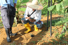
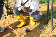
In order for Eco Starland to understand and master the important work of land management of the 315 acres EcoFarm in the hinterland, we have invited licensed professionals to visit the site for soil surveys, including cadastral survey, topographic survey, land leveling measurement, and other land resource surveys. Early in the morning, soil survey experts went to work in the farm along with other Eco Starland staff.
Firstly, the expert started working on the outside of the EcoFarm with a device. Soil survey is the use of surveying and remote sensing technique to determine boundaries, locations, areas, elevations and distributions, topographic surveys and mapping of land. This job is very precise, demanding, and should be executed with extreme caution. The scope of measurements includes actual land quantity, land distribution, land situation etc., and mapping work will be done with the measurement results taken.
The aim of this project is to get the best space and care for each and every Musang King Durian tree that is planted, and for it to grow in an outstanding environment. Sufficient space for each plant is crucial, as it can provide abundant moisture, nutrients and sunlight. Eliminating concentrated planting will result in the avoidance of looting growth space and competition for nutrients between plants. Accurate soil surveyance and planning makes the management of Eco Starland’s farm simpler and more sophisticated, therefore making your durian experience more thorough and enjoyable.
In addition, Eco Starland’s staff also took pictures of the soil surveys process and the durian trees in the farm for recording. In the near future, EcoFarm will be setting up a green forest and it will be full of fruits, becoming a golden farm with vitality.
2019年4月2日-彭亨文德甲讯。
易盛集团为了掌握腹地315英亩易盛园土地管理的重要工作,特别邀请持牌专业人员实地走访进行土地测量,包括地籍测量、地形测量、土地利用现状测量、土地平整度测量、荒山荒地等后备土地资源调查等。一大清早,土地测量的专家随同易盛工作人员进入果园进行工作。
首先专人携带仪器在易盛园果园外围展开作业。土地测量是运用测量学和遥感技术方法对土地及其附着物的界限、位置、面积、高程和分布、地形测量与制图工作。 这项工作一点都马虎不得,要求严格,精准和仔细。 测量的范围包括实际土地数量、土地分布、土地形势等,最后进入绘图工作。
这项工程无非是为了让种下的每一棵猫山王都获得最佳的空间和照顾,在优良的环境下成长。足够的空间,可以有效提供丰沛的水分,营养成分及阳光。排除密集种植,造成抢夺生长空间的情况发生。 精准的土地测量与规划让易盛集团的果园管理更加简单及完善。
此外,易盛集团的工作人员也不忘在果园拍照记录土地测量过程以及榴梿树的生长情况。不久的将来,易盛园将绿树林立并且结满累累硕果,成为一片绿意盎然又生机活现的黄金果园。


Comments